
Calibrating GPS signal
When calibrating the GPS signal, the GPS receiver must be in the exact same position as that when setting the Reference point.


When should you calibrate?
You will need to calibrate the GPS signal in the following instances:
- ▪
- Each time before starting work
- ▪
- When you find that a deviation is shown on the screen even when driving down a swath.
 function icon
Procedure
- 1.
- Drive to the reference point at the entrance to the field.
- 2.
- Position the tractor with both of its front wheels on the line.
The tractor must be positioned at the same angle as when the reference point was set. The distance from the fixed permanent point on the roadside must be the same as when the reference point was set.
 - Press.
 - Press.
 - Press.
- ⇨
- The program will need 15 seconds to determine the current position. Re-calibrating the reference point overwrites the old calibration.
 - Back
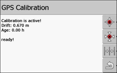
The GPS calibration screen now displays the following parameters:
- ▪
- Drift
- Displays the reference point drift since the reference point was set. All field data will be shifted by this value. The drift is re-calculated when the GPS signal is calibrated.
- ▪
- Age
- How many hours have passed since the GPS signal was last calibrated. Hundredths of a hour are displayed behind the decimal point. For example: 0.25 h = one quarter of an hour = 15 minutes